> ## Documentation Index
> Fetch the complete documentation index at: https://help.polygon-one.com/llms.txt
> Use this file to discover all available pages before exploring further.
# Upload Evidence
> Upload documents and geodata for EUDR compliance
## Overview
Through the **evidence upload**, you upload the required compliance evidence for your EUDR-relevant articles. Polygon One automatically analyzes uploaded documents with AI and classifies them accordingly.
## Uploading Documents
### Supported Formats
* PDF documents
* Images (PNG, JPEG, TIFF)
* Text files
* CSV
* GeoJSON (for geodata)
* Maximum file size: **10 MB**
### Examples of Accepted Documents
* FLEGT licenses
* FSC/PEFC/ISCC/Rainforest Alliance certificates
* Land ownership titles and usage rights
* Harvesting permits and environmental approvals
* Customs declarations
### Uploading Evidence
Navigate to the article you want in the compliance dashboard.
Click **"Upload evidence"** and select the file.
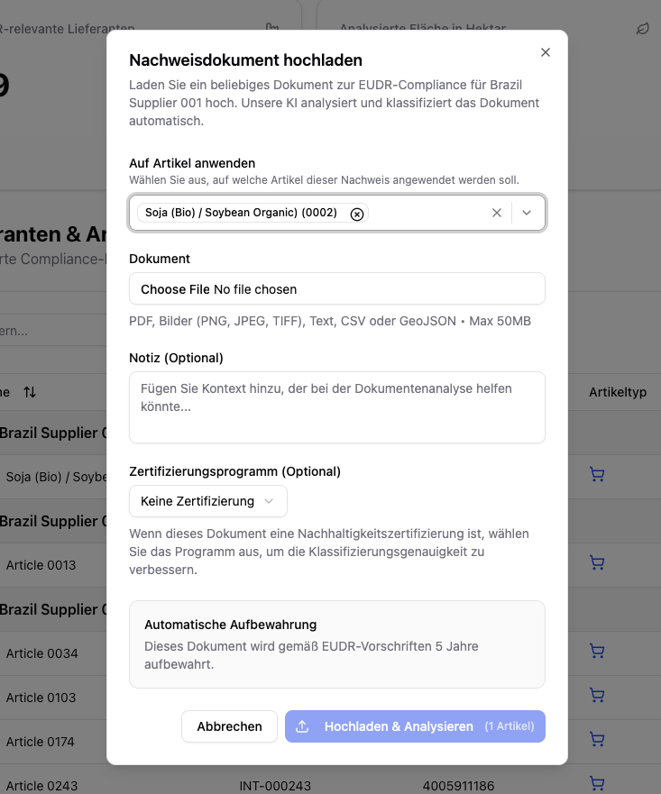 If the document is a sustainability certification, select the **certification scheme** (e.g. FSC, PEFC, RSPO). This improves classification accuracy.
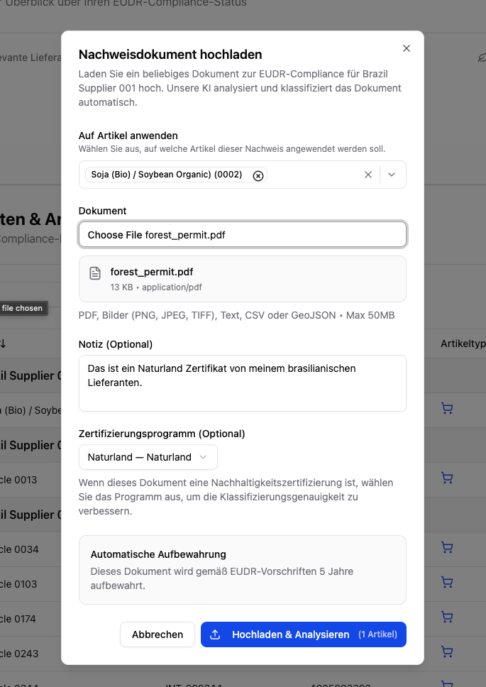 Add context that could help with the document analysis (e.g. "Certificate of origin for shipment #12345").
Click **"Upload & Analyze"**. The AI automatically analyzes and classifies the document.
Uploaded documents are automatically **retained for 5 years** in accordance with EUDR regulations.
### Certifications
When you upload a sustainability certification (e.g. FSC, PEFC, ISCC), Polygon One automatically analyzes which **legal compliance categories** are covered by the certificate:
* Land use rights
* Environmental protection
* Forestry regulations
* Third-party rights
* Labor and human rights
* Taxes, trade, and customs
* Anti-corruption
Covered categories are automatically pre-marked in the legal questionnaire.
If there are significant inconsistencies in the uploaded document, these are detected and flagged by our analysis. In this special case, we cannot automatically recognize the document; instead, it must be confirmed by
you through a manual review. You can find more details about this process here:
### Certificate Register Check (FSC/PEFC)
When you upload an **FSC or PEFC certificate**, Polygon One automatically checks the license against the **official register** and shows the result as a read-only **badge** — everywhere the certificate appears (document list, detail view, upload dialog, supplier portal).
| Badge | Meaning |
| ----------------------------------------------- | ------------------------------------------------------------------------------------ |
| **Confirmed in register** | The license is valid in the register and the holder matches. |
| **Holder name differs** | The license is valid, but the registered holder differs — manual review recommended. |
| **License invalid / expired / not in register** | The register does not confirm the license as valid — manual review required. |
| **Live check unavailable** | The live check could not be completed; the pattern check was applied instead. |
The register check is purely **informational**: it does not trigger any action and does not affect the compliance status. It runs in the background; the badge always shows the most recently stored result.
## Capturing Geodata
Geodata (production locations) are a central component of EUDR compliance. You can provide geodata in several ways:
### Drawing Geodata on the Map
Navigate to the article and open the map view.
Click **"Draw area"** and mark the corner points of your production area on the map. Press **Escape** to cancel drawing.
Add context that could help with the document analysis (e.g. "Certificate of origin for shipment #12345").
Click **"Upload & Analyze"**. The AI automatically analyzes and classifies the document.
Uploaded documents are automatically **retained for 5 years** in accordance with EUDR regulations.
### Certifications
When you upload a sustainability certification (e.g. FSC, PEFC, ISCC), Polygon One automatically analyzes which **legal compliance categories** are covered by the certificate:
* Land use rights
* Environmental protection
* Forestry regulations
* Third-party rights
* Labor and human rights
* Taxes, trade, and customs
* Anti-corruption
Covered categories are automatically pre-marked in the legal questionnaire.
If there are significant inconsistencies in the uploaded document, these are detected and flagged by our analysis. In this special case, we cannot automatically recognize the document; instead, it must be confirmed by
you through a manual review. You can find more details about this process here:
### Certificate Register Check (FSC/PEFC)
When you upload an **FSC or PEFC certificate**, Polygon One automatically checks the license against the **official register** and shows the result as a read-only **badge** — everywhere the certificate appears (document list, detail view, upload dialog, supplier portal).
| Badge | Meaning |
| ----------------------------------------------- | ------------------------------------------------------------------------------------ |
| **Confirmed in register** | The license is valid in the register and the holder matches. |
| **Holder name differs** | The license is valid, but the registered holder differs — manual review recommended. |
| **License invalid / expired / not in register** | The register does not confirm the license as valid — manual review required. |
| **Live check unavailable** | The live check could not be completed; the pattern check was applied instead. |
The register check is purely **informational**: it does not trigger any action and does not affect the compliance status. It runs in the background; the badge always shows the most recently stored result.
## Capturing Geodata
Geodata (production locations) are a central component of EUDR compliance. You can provide geodata in several ways:
### Drawing Geodata on the Map
Navigate to the article and open the map view.
Click **"Draw area"** and mark the corner points of your production area on the map. Press **Escape** to cancel drawing.
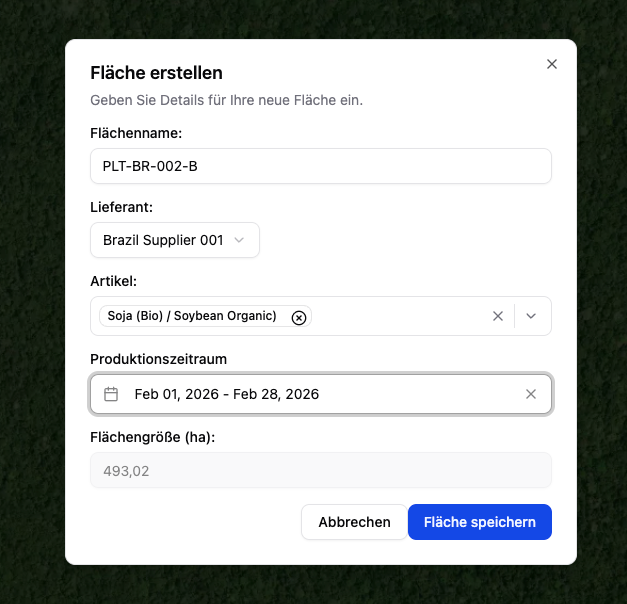 Enter the area name, supplier, article, the scientific name if applicable (required for wood), and the production period.
Confirm the details and save the area. The satellite analysis starts automatically.
### Importing Geodata
Alternatively, you can import geodata as a file. To do so, click the upload icon at the top left.
Enter the area name, supplier, article, the scientific name if applicable (required for wood), and the production period.
Confirm the details and save the area. The satellite analysis starts automatically.
### Importing Geodata
Alternatively, you can import geodata as a file. To do so, click the upload icon at the top left.
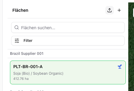 We accept the following file formats:
* **GeoJSON** — upload directly
* **CSV/XLSX with WKT geometry** — via the import function under **Settings → CSV Imports → Areas**
We accept the following file formats:
* **GeoJSON** — upload directly
* **CSV/XLSX with WKT geometry** — via the import function under **Settings → CSV Imports → Areas**