> ## Documentation Index
> Fetch the complete documentation index at: https://help.polygon-one.com/llms.txt
> Use this file to discover all available pages before exploring further.
# Risk Assessment
> How Polygon One automatically detects deforestation and legal risks
## Overview
Once geodata and legal information have been received, Polygon One automatically performs a comprehensive risk assessment. The system distinguishes between **geographic risks** (deforestation and forest degradation) and **legal risks** (violations of country-specific laws). Both dimensions must be satisfied for an article to be considered **compliant**.
## Geographic Risk Assessment
Polygon One analyzes the submitted production areas using several satellite data sources. The goal is to determine whether deforestation or forest degradation has occurred on the areas after the cut-off date of **31 December 2020**.
### Satellite Data Sources Used
| Data source | What is analyzed |
| ----------------------------- | -------------------------------------------------------------------------------------------------- |
| **ESA WorldCover** | Land cover classification (cropland, forest, water, settlement, grassland) |
| **JRC Global Forest Cover** | Forest type detection (primary forest, natural forest, plantation forest) |
| **GFT Forest Type** | Degradation analysis — distinguishes between primary forest, natural forest, and plantation forest |
| **TMF Tropical Moist Forest** | Detection of deforestation and degradation in tropical moist forests |
| **PALSAR Radar** | Independent forest confirmation using radar (low/medium/high risk) |
In addition, **plausibility checks** are performed — for example, whether the area overlaps with urban areas or bodies of water.
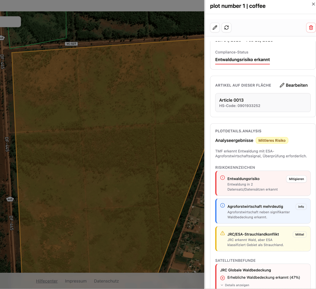
### Possible Geo Risk Indicators
After the analysis, production areas are tagged with risk indicators:
| Risk indicator | Description |
| ------------------------------ | ---------------------------------------------------------------- |
| **Forest detected** | JRC detects forest cover on the area |
| **Primary forest degradation** | GFT detects primary forest — harvesting poses a degradation risk |
| **Natural forest degradation** | GFT detects naturally regenerating forest |
| **TMF deforestation detected** | TMF detects deforestation activity after the cut-off date |
| **TMF degradation detected** | TMF detects a degraded area |
| **Agroforestry ambiguous** | Agroforestry alongside significant forest cover |
 ### Area Status After Analysis
| Status | Meaning |
| ------------------------- | -------------------------------------------------------------------- |
| **No deforestation risk** | Satellite analysis confirms: no deforestation after the cut-off date |
| **Deforestation risk** | The analysis detected potential deforestation or degradation |
| **Analysis pending** | The area has been submitted, the satellite analysis is still running |
| **Review pending** | Risk mitigation submitted, awaiting review |
| **Risk mitigated** | A risk was detected but successfully mitigated through evidence |
## Legal Risk Assessment
In addition to the geographic analysis, the system checks legal compliance based on the questionnaire and the submitted documents. Risks are identified per **risk category** of the respective production country.
### Legal Risk Categories
| Category | Examples of relevant evidence |
| ---------------------------------------------------- | ----------------------------------------------------------------- |
| **Land use rights & ownership** | Land ownership titles, lease agreements, usage permits |
| **Environmental & nature conservation laws** | Environmental permits, environmental impact assessments |
| **Forestry law & timber use** | Forest management plans, logging permits (only for wood products) |
| **Rights of third parties & indigenous communities** | Consultation records, declarations of consent |
| **Labor & human rights** | Labor inspection reports, social audits |
| **Tax, trade & customs regulations** | Tax certificates, export permits |
| **Anti-corruption & document authenticity** | Compliance declarations, audit reports |
| **Additional compliance measures** | Additional regulatory evidence |
### Area Status After Analysis
| Status | Meaning |
| ------------------------- | -------------------------------------------------------------------- |
| **No deforestation risk** | Satellite analysis confirms: no deforestation after the cut-off date |
| **Deforestation risk** | The analysis detected potential deforestation or degradation |
| **Analysis pending** | The area has been submitted, the satellite analysis is still running |
| **Review pending** | Risk mitigation submitted, awaiting review |
| **Risk mitigated** | A risk was detected but successfully mitigated through evidence |
## Legal Risk Assessment
In addition to the geographic analysis, the system checks legal compliance based on the questionnaire and the submitted documents. Risks are identified per **risk category** of the respective production country.
### Legal Risk Categories
| Category | Examples of relevant evidence |
| ---------------------------------------------------- | ----------------------------------------------------------------- |
| **Land use rights & ownership** | Land ownership titles, lease agreements, usage permits |
| **Environmental & nature conservation laws** | Environmental permits, environmental impact assessments |
| **Forestry law & timber use** | Forest management plans, logging permits (only for wood products) |
| **Rights of third parties & indigenous communities** | Consultation records, declarations of consent |
| **Labor & human rights** | Labor inspection reports, social audits |
| **Tax, trade & customs regulations** | Tax certificates, export permits |
| **Anti-corruption & document authenticity** | Compliance declarations, audit reports |
| **Additional compliance measures** | Additional regulatory evidence |
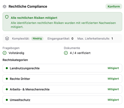 Recognized **sustainability certifications** (FSC, PEFC, SFI, ISCC, Rainforest Alliance, RSPO, Fairtrade, RTRS, EU Organic) can automatically cover multiple legal categories. For **wood products from FLEGT VPA countries**, a valid FLEGT license fulfills all legal categories at once.
## Compliance Dashboard
Once the analysis is complete, the **compliance dashboard** (inbound) shows a complete overview:
Recognized **sustainability certifications** (FSC, PEFC, SFI, ISCC, Rainforest Alliance, RSPO, Fairtrade, RTRS, EU Organic) can automatically cover multiple legal categories. For **wood products from FLEGT VPA countries**, a valid FLEGT license fulfills all legal categories at once.
## Compliance Dashboard
Once the analysis is complete, the **compliance dashboard** (inbound) shows a complete overview:
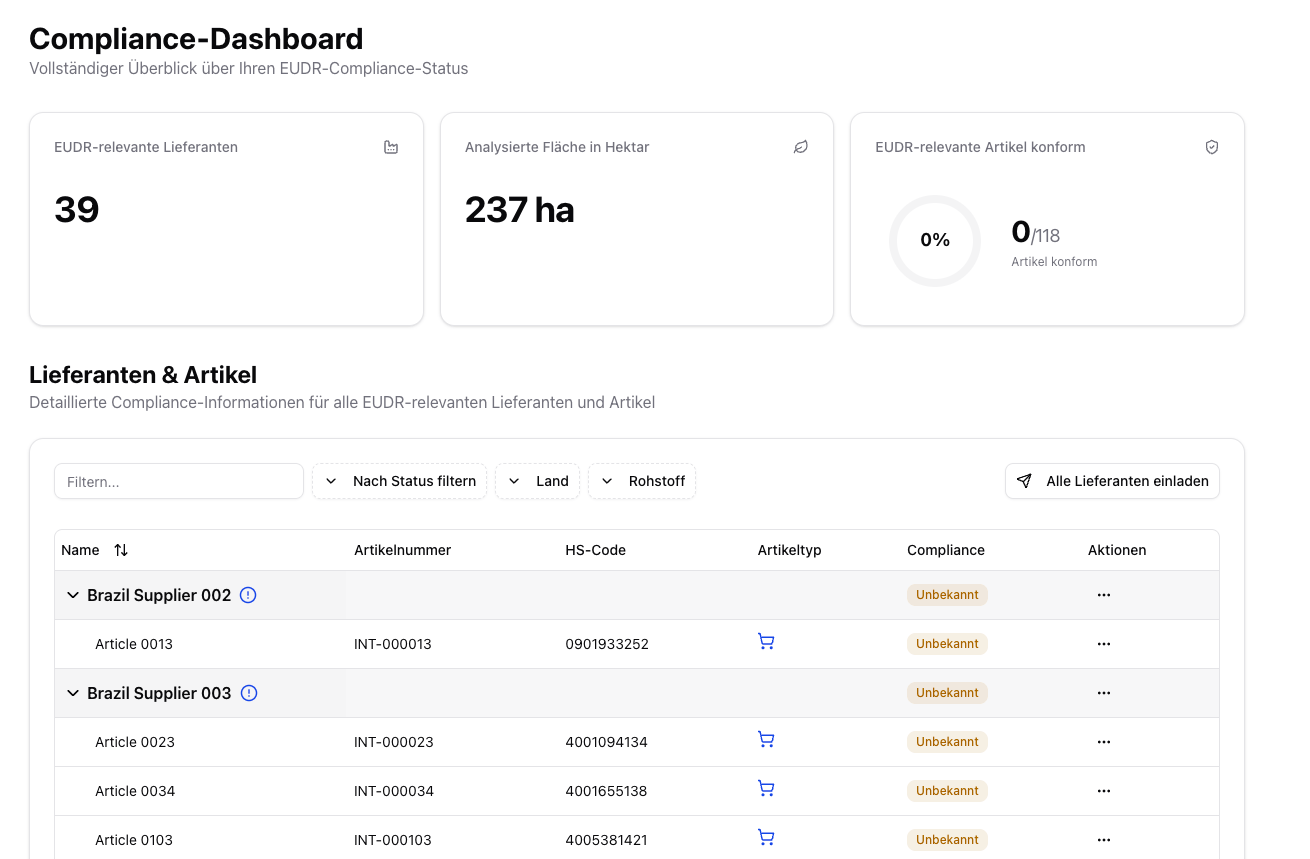 * **EUDR-relevant suppliers** — number of affected suppliers
* **Analyzed area** — total area in hectares
* **Compliant articles** — number of compliant EUDR-relevant articles
* **Pending actions** — articles with missing geodata, missing legal analysis, or a missing report
## Compliance Status per Article
In the **compliance dashboard** (inbound), you see the overall status for each article:
| Status | Meaning |
| --------------------- | ---------------------------------------------------------------------------- |
| **Compliant** | Geo and legal compliance fulfilled — ready for DDS |
| **Non-compliant** | Deforestation risk or legal deficiencies detected — risk mitigation required |
| **Review pending** | Data has been submitted, analysis is running |
| **Unknown** | Missing data or documentation — further information required |
| **Not EUDR-relevant** | The article does not fall under the EUDR |
* **EUDR-relevant suppliers** — number of affected suppliers
* **Analyzed area** — total area in hectares
* **Compliant articles** — number of compliant EUDR-relevant articles
* **Pending actions** — articles with missing geodata, missing legal analysis, or a missing report
## Compliance Status per Article
In the **compliance dashboard** (inbound), you see the overall status for each article:
| Status | Meaning |
| --------------------- | ---------------------------------------------------------------------------- |
| **Compliant** | Geo and legal compliance fulfilled — ready for DDS |
| **Non-compliant** | Deforestation risk or legal deficiencies detected — risk mitigation required |
| **Review pending** | Data has been submitted, analysis is running |
| **Unknown** | Missing data or documentation — further information required |
| **Not EUDR-relevant** | The article does not fall under the EUDR |
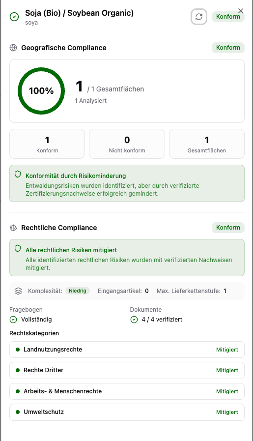 An article is only **compliant** when:
1. All production areas pass the geographic analysis (or risks are mitigated)
2. All legal compliance categories are fulfilled
3. The entire supply chain has been assessed
## Next Steps
If risks have been detected, they must be mitigated before a DDS can be created:
Mitigate detected risks with the mitigation dialog.
Generate and download compliance reports.
An article is only **compliant** when:
1. All production areas pass the geographic analysis (or risks are mitigated)
2. All legal compliance categories are fulfilled
3. The entire supply chain has been assessed
## Next Steps
If risks have been detected, they must be mitigated before a DDS can be created:
Mitigate detected risks with the mitigation dialog.
Generate and download compliance reports.